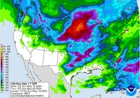
Record Rains headed to California.. just like 2011.
Daily records for temperature and rainfall totals were tied and broken Tuesday as a storm system hit Southern California.
The low temperature at UCLA was 49 degrees, tying a record set in 1962, according the National Weather Service.
A record rainfall total for the day was set at Los Angeles International Airport. Tuesday's 0.23 inches of rain at LAX eclipsed a record of 0.12 inches that had stood since 1949, the Weather Service said.
Long Beach Airport received 0.25 inches of rain, breaking a record of trace rainfall set in 2004.
In Ventura County, Camarillo had 0.19 inches of rain. The previous record was 0.12 inches set in 1994.