|

| I've never had much success trying to make a VR planting map that I liked by using yield maps alone. I have rolling hills like you, and I approached my VR planting prescriptions like this:
Increase planting pop in the high fertility areas at the bottoms of the hills
Lower pops on the eroded sidehills
Have a medium/high pop on the upland flat areas
First you need to determine the population that each of those areas will support and make a mental note of that.
Next, I used several types of spatial maps to give me a "base map" to assign rates. I used yield maps, topographical maps(Elevation), and my own field knowledge.
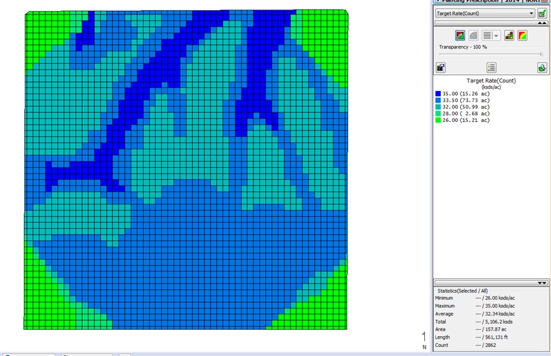
Now, for actually writing my prescriptions I use 50' grids. I try and get close to my finished map by using a yield map or something, but then I go to "edit" the layer and I will manually assign rates to each 50' square grid. That allows me to customize each map within 50' of field/soil conditions. Then I print those prescription maps off and carry them with me in the tractor cab. That allows me to see where i might need to make adjustments in my grid assignments when I'm actually in the field. Sometimes I end up with too high/low of a rate in some areas, and if you mark up your map while you are actually planting, then you won't make the same mistake next year.
It takes a little more work on year #1 making all those maps and manually assigning the rates, but it provides a fantastic foundation and easy customization map to build upon in future years.
 (Capture.PNG) (Capture.PNG)
Attachments
----------------
 Capture.PNG (126KB - 288 downloads) Capture.PNG (126KB - 288 downloads)
| |
|
 Variable Rate Planting Prescriptions..Where to start?!

