Dallas Center IA 515-720-2463 | On the device you are using, as phone, I-Pad, etc.
Do you have flight logs as Andrew above said?
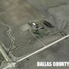
This is one I have. Image is a picture of I-Pad screen.
It shows a flight.
You can go thru the flight just like playing a video.
The H in a green circle is the starting point - Center of image, just to the right of highway.
The Yellow line is the flight path so far during this playback.
The Red arrowhead is the location of the drone.
Picture deals are where I took pictures at.
Could, may should give you a good idea of it’s present location.
Did it not go into Return to Home for lost signal? Maybe a 2 is different.
Did you have the R2H attitude set high enough to clear any trees, tall buildings, hills, etc?
Good luck
 (24JunFL2.JPG) (24JunFL2.JPG)
Attachments
----------------
 24JunFL2.JPG (108KB - 467 downloads) 24JunFL2.JPG (108KB - 467 downloads)
|
 P2 Fly Away

