Dallas Center IA 515-720-2463 | More Info
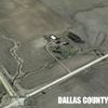
This picture is from a later drone flight with my Spark.
Based on the info from Fine My Drone,
And the last position on the flight log in the table =
I would put the lost Mavic at about the Red arrow.
This is a fairly smooth but not level area. And some grass growing.
The area I felt at the time Wednesday morning was some what in the Yellow oval.
I think it is not stone, but a very hard clay. Well eroded. Steep, hard to walk on.
Go up or down, or sideways very hard.
So hard that I was probably devoting 99% of my effort in just moving around or staying on my feet - Really not looking the area over.
After taking a quick look at the area Find My Drone was showing, I went back and got the table [with Find My Drone] and a camera.
Then walked again from the parking lot where I had my shade deal sit up, back up that pretty steep path - Pretty much along the Black arrows
Down a steep gully side, then around the area.
With the heat I was getting worried about getting back up that steep incline.
Figured out a different route out. Thru the area in the Blue oval, pretty much along the green arrows.
I was Very glad to sit down in the shade after getting back.
It what I am seeing now from Find My Drone and the flight log is correct and the drone is not in that badly eroded area - But on the smooth but not level - The drone should be a lot easier to find.
But I am now about 250 miles to the east. Not worth the drive.
But if I had got a Ogallala motel room this evening vs one way east, I probably would be on the south side of the Jail in the morning.
Really wish somebody in the area would go look.
 (DJI_0533 (full).JPG) (DJI_0533 (full).JPG)
Attachments
----------------
 DJI_0533 (full).JPG (197KB - 356 downloads) DJI_0533 (full).JPG (197KB - 356 downloads)
|
 Find My Mavic Mini and You Can Have It

