Dallas Center IA 515-720-2463 | It is not a premium service.
I can go back to March of 1990. Lots of updates since 2000.
Go to the Clock at the top.
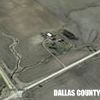
Top image is my farm 9/14/2012
Added later:
I see the Save Image does not include the control icons at the top.
Also know that Google Earth looks different on different machines.
On my Mac laptop the clock is up there with the Ruler for measuring, Print, etc.
The second image below is a Pioneer research farm about a mile west of my place. Date of June 14, 2007
Then the deal shows up on the image, upper left. Within the Red oval.
Move the slider to different dates.
Many of the older images are not the best.
Edited by Robert W Greif 4/7/2016 07:31
 (2012.jpg) (2012.jpg)
 (Pioneer9:7:2007.jpg) (Pioneer9:7:2007.jpg)
Attachments
----------------
 2012.jpg (80KB - 477 downloads) 2012.jpg (80KB - 477 downloads)
Pioneer9:7:2007.jpg (77KB - 486 downloads)
|
 aerial imagery of summer 2012

