West of Mpls MN about 50 miles on Hwy 12 | River traffic on the Mississippi and Minnesota rivers is shutting down due to high water.
The U.S. Army Corps of Engineers has closed Minneapolis locks and dams to recreational boats due to the rising waters of the Mississippi River. Lower St. Anthony Falls Lock and Dam and Lock and Dam 1, located near Minnehaha Falls, reached flows of 30,000 cubic feet per second on Friday. Commercial traffic at those locks continues but will be shut down if flows reach 40,000 cubic feet per second.
CGB Savage, MN located on the MN River is only accepting corn and is no longer loading barges.
There are many road closures across the State of MN because of flooding...sucks when most all tile outlets are foot or more under water.
A report from MNDNR through the end of May 2024...big rains have continued to fall the entire month of June with more heavy rainfall events than what we experienced in May.
https://www.dnr.state.mn.us/climate/journal/index.html
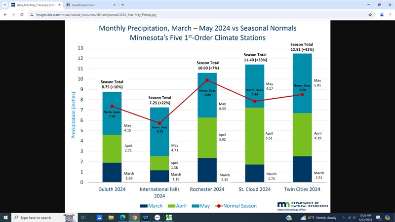
Beginning around March 21, however, a much more active pattern set up across the region. A sprawling winter storm March 23-27 dropped heavy snow and rain over a large area, effectively doubling seasonal snowfall and precipitation totals in many areas, and reversing the winter precipitation deficits caused by the prolonged winter dry spells. Each of Minnesota's five "first-order" stations ended March with above-normal precipitation, as did the southeastern 2/3 or so of the state.
From that point, right through the end of May, Minnesota had a steady diet of precipitating weather systems, generally coming every 3-5 days--sometimes arriving daily, and occasionally separated by a week or so. These were predominantly rain-making weather systems, and because Minnesota tended to be on the cooler side of the passing systems, the rain was typically steady and of light to moderate intensity. Heavier rains associated with thunderstorms began affecting the state towards the end of May, but most of the wet spell through May took place without significant flash flooding.
The proportion of the state with above-normal precipitation grew to about 90% during April, with only the far north and a small part of the southeast coming in dry. St. Cloud more than doubled its normal precipitation, as did many communities in central Minnesota, and also along the Red River in the northwest.
In May, the parade of wet systems continued, with mostly steady rains during the first three weeks or so of the month, but more thunderstorms and downpours arriving as the month ended. At least 95% of Minnesota saw above-normal precipitation, with areas all over the state receiving precipitation amounts that were more than 50% above normal.
Virtually the entire state of Minnesota had above-normal precipitation for the spring season, March through May. Many stations, in all regions of Minnesota, exceeded normal precipitation for the season by at least 50%. The largest proportional surplus at any station with a complete record was in Milan, along Highway 7 in extreme western Chippewa County, where the 13.68 inches of spring precipitation exceeded normal precipitation by 93%, or 6.60 inches.
There is more big rain forecast for later today here...again...oh well.
Edited by CMN 6/22/2024 10:42
 (Screenshot (87) (full).png) (Screenshot (87) (full).png)
 (Screenshot (88) (full).png) (Screenshot (88) (full).png)
Attachments
----------------
 Screenshot (87) (full).png (67KB - 10 downloads) Screenshot (87) (full).png (67KB - 10 downloads)
Screenshot (88) (full).png (135KB - 11 downloads)
|
 Flooding in 24 compared to 15?

