So it FINALLY looks like La Nina is on the way out the door.. (good riddance!!)
https://www.climate.gov/news-features/blogs/enso/march-2018-enso-update-come-water%E2%80%99s-fine
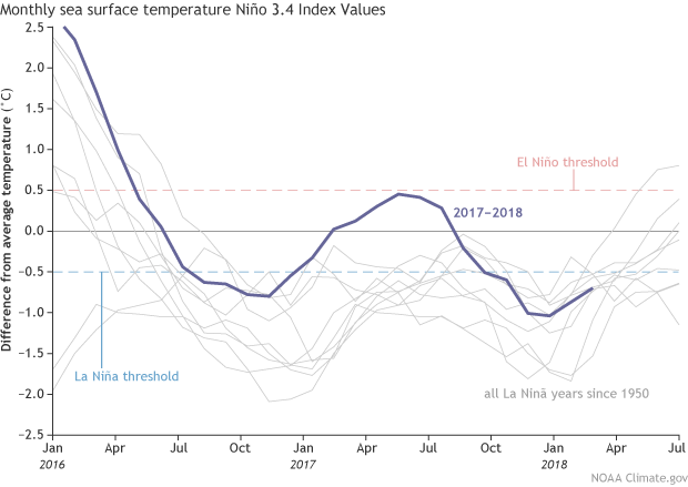
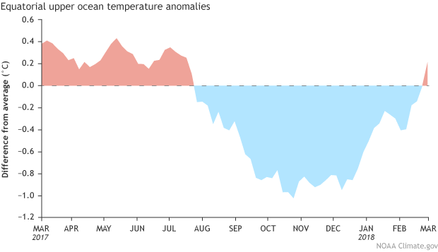
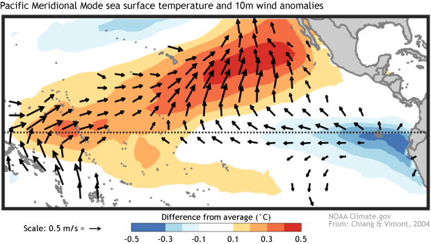
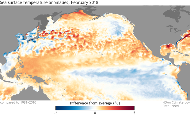
March 2018 ENSO update: come on in, the water’s fineThe great La Niña of 2017–18 is dwindling, and forecasters expect the return of neutral conditionsby the March–May season, estimated at about 55% likelihood. Neutral conditions are favored to continue through the summer. It’s too early to get a picture of next fall and winter, due to the spring predictability barrier and the absence of strong signs one way or the other. There are a few interesting features we’ll watch closely over the next few months… but first, this update on current conditions! Stick your toe inLa Niña may be weakening, but she’s still making an impression on the average sea surface temperature in the equatorial Pacific. The Niño3.4 index, which measures the departure of sea surface temperature from the long-term average in the east-central equatorial Pacific, was about -0.7°C during February, using the ERSSTv5 dataset (our most consistent long-term sea surface temperature record.) The atmospheric elements of La Niña diminished over February, with the amount of rain and clouds the central Pacific returning to near-normal, and Indonesia actually somewhat drier than average. This is a change from the La Niña-related suppressed rainfall in the central Pacific and greater-than-average rainfall over Indonesia and that was in place over the winter. More evidence that La Niña’s enhanced Walker circulation patterns are fading appeared in the average near-surface winds over the west and central Pacific: these winds were weaker than average during February. (La Niña’s effect is to strengthen the near-surface winds.) It’s likely that the active Madden-Julian Oscillation that Michelle chronicled last month played into the average February patterns. The MJO is an area of increased storminess that travels eastward along the equator and can circle the planet in about 1-2 months. Near-surface winds tend to blow toward this stormy area, meaning the area behind the MJO experiences more west-to-east wind. When the MJO is moving through the Pacific and into the western hemisphere, as it was during most of February, we can see the average wind patterns in the western and central Pacific become more westerly. Recently, the MJO has weakened substantially. Making wavesOne of the many elements of the Pacific ocean-atmosphere system that ENSO forecasters monitor pretty closely is the temperature of the water below the surface. Colder than the long-term average since August 2017, these waters crept to above normal temperatures in February. The warming was related to an eastward-moving warmer-than-average blob primarily located between 250 and 50 meters below the surface of the western Pacific Ocean… a downwelling Kelvin wave! As this wave sloshes east under the surface, it will continue to erode the supply of cooler-than-average waters available for La Niña, providing more confidence in the forecast for neutral conditions to develop this spring. If you feel inclined to examine subsurface temperature anomalies over the past almost-40 years, I’d encourage you to check out my Climate Prediction Center colleague Yan Xue’s great resource for ocean observations. Pool partyA while ago we were introduced to the Pacific Meridional Mode (PMM for short). In a nutshell, a positive PMM is a pattern of warmer-than-average sea surface temperatures stretching west from Baja California across the Pacific Ocean contrasted with cooler-than-average temperatures along the equator and into the southern hemisphere… In fact, the Pacific Meridional Mode index (maintained by our guest blog author Dan Vimont) is the most positive it’s been in years. The contrast between warmer north and cooler south can influence wind patterns along the equator, thereby influencing ENSO. Of course, the global climate system is big and complicated, and it’s too early to say if this strong PMM will be a major factor as the year goes on… but you can bet we’ll be watching it. If you’d like to compare ocean temperature patterns from this year to the past, you can visit Climate.gov’s Data Snapshots; they also have a nice display of recent temperature and precipitation patterns. Another related resource is NOAA’s Environmental Visualization Lab (select “Add Data” then “climate”). And, of course, here at the blog we’ll keep you posted on all things ENSO.
Color me Skeptical.. but I wasn't gonna make much of this UNTIL I SAW PROOF!! We FINALLY got some Spring like moisture this weekend.. NOT enough.. but it's a start..
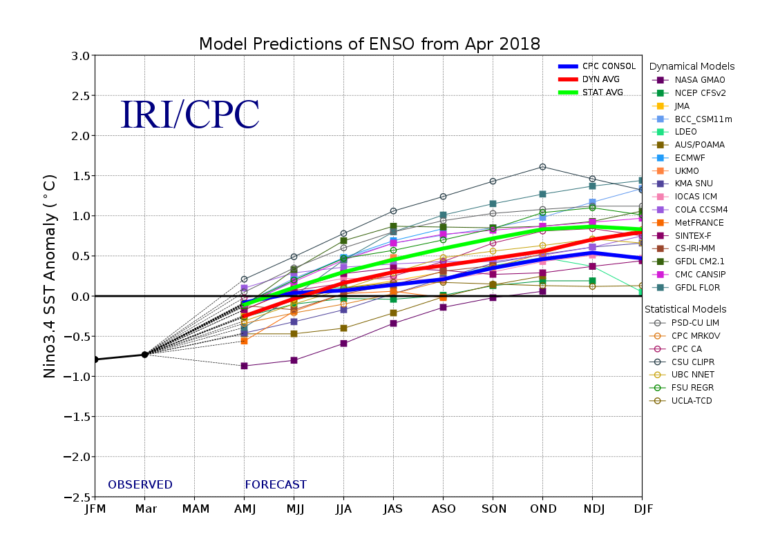
Now almost ALL of the models are pointed upward.. What that means.. for HRW Wheat producers this Spring.. and Summer for Fall crops..??? I Do not know.. (again I'm not a meterologist..)
( https://iri.columbia.edu/our-expertise/climate/forecasts/enso/curren... )
 But it's got to be better than the La Nina outlook (right?) The Thing that was Freaking me out was this La Nina.. we planted late and ran out of heat units to get the crop fully established. On the March 19th event we got enough moisture to even SPROUT some more.. "huh.. well that's good.. thunked it winterkilled.. turned out it NEVER EMERGED!! whew.." But it's got to be better than the La Nina outlook (right?) The Thing that was Freaking me out was this La Nina.. we planted late and ran out of heat units to get the crop fully established. On the March 19th event we got enough moisture to even SPROUT some more.. "huh.. well that's good.. thunked it winterkilled.. turned out it NEVER EMERGED!! whew.."
Now that said.. we still got some challenges..
ONE is that we may have MISSED our spring moisture to pump sufficient precip into the area before the Summer heat turns it ON..???
But then again we still got the Wetter part of our SPRING to come.. so.. "odds say" we should still get "something."
"Jon SCKs you changing your tune?"
No.. just showing why things "may" be changing so come harvest.. If/when.. my neighbor who thinks that the whole drought thingy was overblown.. turns out to be correct.. (of course he was priced.. "uh hum.") We'll find out.. there's starting to be some evidence that he "could" be correct..?? but THIS TREND NEEDS TO CONTINUE!!
"Ya'll are ALWAYS Crying drought.. "
Comes with the territory.. some years we just DON'T get a Chance to grow much.. 2011.. 2012.. 1989.. as well as others come to mind.
"Farming in SW Kansas.. you Lose $$$ 3 years out of 10.. break even on 5.. and make enough on the remaining 2 to see you through the next 10 years.." C Angel Plains Kansas
which.. I've found to be basically true through my career. Good Crops.. and Good Prices.. come when they come.. GOOD LUCK!! Trying to predict them..
Now if the WIND comes back up next week.. and it's 95 plus.. I reserve the right to come back and plead my case.. "We're all gonna DIE out here.."
lol..
https://www.youtube.com/watch?v=BfbIoUMdKZ0
but you probably already knew that.. ;-)
Edited by JonSCKs 4/22/2018 17:25
|  Rainfall Amounts in Southern HRW Belt this weekend?

