East Central Ia | I have imported all my soil sample data into SMS Advanced but am running into a few problems.
I have a few fields that I cleaned up and instead of having a North, South, East field... I merged them into one field for easier management.
But my soil sample shape files are separate for each field... So to map the whole field I have to load three different soil sample shape files by adding them each to the current map.
My problem is that it wants to fill that data from each file all the way out the field boundary and that makes my data all messed up. It will take 5 sample points for the north field and then stretch them all down and into the south, or east field to the boundary edges.
If I go into the layer options and turn that off so it doesn't fill to the boundary edge I have gaps all over the place.
Is there a way I can merge those layers into one layer or do I have to find some separate software to merge shape files and reload them into SMS?
This particular field was split between crops in the past, its now all one crop. So my SMS software has it with a North, Middle, and South fields. I have since merged them all into one and this is what I get.
Edited by bleedred 2/3/2016 12:46
 (Fill to edge off.jpg) (Fill to edge off.jpg)
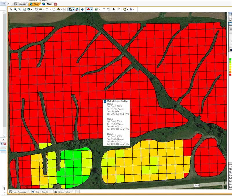 (Fill to edges on.jpg) (Fill to edges on.jpg)
Attachments
----------------
 Fill to edge off.jpg (189KB - 79 downloads) Fill to edge off.jpg (189KB - 79 downloads)
Fill to edges on.jpg (172KB - 79 downloads)
|
 SMS soil sample questions... Pics

