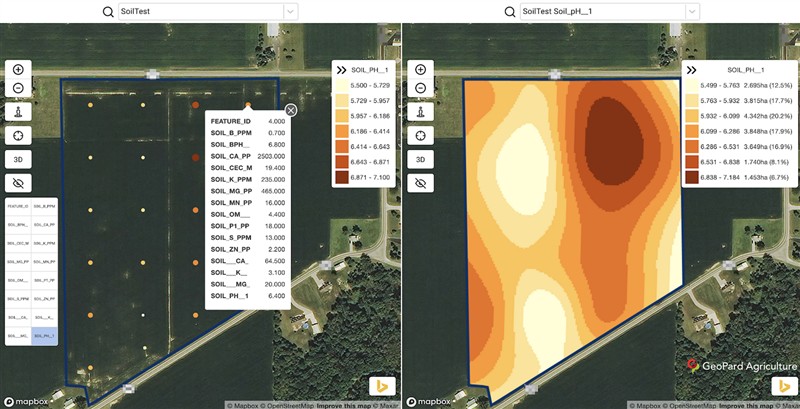
Hi all, We invite you to use and test our soil data analytics module. See blog post https://geopard.tech/blog/tpost/4mrusrcit2-soil-module You can upload soil sampling files into GeoPard Agriculture and get an easy-readable heatmap visualization of each attribute in the soil sampling dataset. In addition, you can delineate management zones based on any attribute, compare them with other layers like historical crop productivity and build variable rate fertilizer prescription files. First 500 acres are free to use. We don't charge additionally for this module, flat rate is $0.25 per acre per year and includes: - satellite data analytics (30 years of data, Landsat and Sentinel). Automated multi-year zones and manual creation of management zones based on any chosen images. We support a lot of indices, not just, see ndvi https://geopard.tech/blog/tpost/s30enmsdy3-satellite-monitoring
- topography analytics https://geopard.tech/blog/tpost/aff9so1a94-topography-and-relief-ana...
- Stability/variation zones https://geopard.tech/blog/rvi
- Heterogeneity analysis https://geopard.tech/blog/tpost/ravbznpi62-heterogeneity-factor
- Yield data visualization and analytics (don't have blog post yet, but it is already working module)
- Unlimited amount of maps, analyses, downloads, views - Sharing of data between accounts
.. and some more, and more to come (multi-layer analytics for example). We build software for precisonAg since 2012 (powerzones by AgriTrend, then Xarvio). We don't share with others or resell your data.
You can self sign-up using link or contact us to assist with account creation and boundaries importing and support with any geospatial analytics for your farm. Take care, Dmitry
Edited by GeoPardAg 4/5/2020 05:26
 (GeoPard soil analytics1 (full).png) (GeoPard soil analytics1 (full).png)
 (GeoPard soil analytics2 (full).png) (GeoPard soil analytics2 (full).png)
 (GeoPard soil analytics3 (full).png) (GeoPard soil analytics3 (full).png)
 (GeoPard soil analytics4 (full).png) (GeoPard soil analytics4 (full).png)
Attachments
----------------
 GeoPard soil analytics1 (full).png (112KB - 365 downloads) GeoPard soil analytics1 (full).png (112KB - 365 downloads)
GeoPard soil analytics2 (full).png (117KB - 382 downloads)
GeoPard soil analytics3 (full).png (99KB - 375 downloads)
GeoPard soil analytics4 (full).png (90KB - 383 downloads)
|  Soil data analytics module, invitation to test

