Dallas Center IA 515-720-2463 | The section in WJKEIGER’s downloaded image is not the dam that was washed out.
But it is a section of highway 281, north of Spencer with a stream.
The dam is about five miles south of Spencer. On south of the Dogleg.
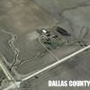
Top image is a GoogleEarth of the section of 281 with the dam and Niobrara River bridge.
Second: Showing both locations with ‘Tacks’
North of town is where WJKEIGER posted, labeled ‘OP’
South the dam and Niobrara River bridge - labeled ‘DAM’
Number three is WJKEIGER’s area, just north of Spencer on 281.
 (SD-3 (full).jpg) (SD-3 (full).jpg)
 (SD-1 (full).jpg) (SD-1 (full).jpg)
 (SD-2 (full).jpg) (SD-2 (full).jpg)
Attachments
----------------
 SD-3 (full).jpg (114KB - 63 downloads) SD-3 (full).jpg (114KB - 63 downloads)
SD-1 (full).jpg (109KB - 55 downloads)
SD-2 (full).jpg (115KB - 59 downloads)
|
 281 bridge spencer Nebraska dam pictures

