NE South Dakota Clark, SD | Unfortunately inexpensive and accurate don't fit in the same product. I have used Drone Deploy with an Ag Eagle drone. Some of the elevations are pretty good and some are pretty bad. I have one of my dads fields that I flew and have RTK collected elevation data for it also. In places it was +/- 2/10's of a foot. In other places it was +/- 2 feet. The general lay of the land was correct, elevations were not. I flew a field for a customer, that I have LIDAR available for. It was not very pretty as you will see in the pictures below. I have also use SRTM elevation data that looks pretty good, but is only 10 meter resolution.
Edited by gpsdude 12/23/2015 10:34
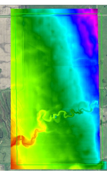 (Beaver LIDAR.jpg) (Beaver LIDAR.jpg)
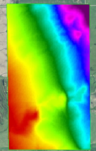 (Beaver SRTM.jpg) (Beaver SRTM.jpg)
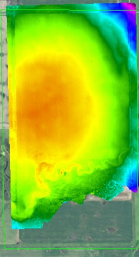 (Beaver Drone.jpg) (Beaver Drone.jpg)
 (Dad Sec 22 SE RTK.jpg) (Dad Sec 22 SE RTK.jpg)
 (Dad Sec 22 SE SRTM.jpg) (Dad Sec 22 SE SRTM.jpg)
 (Dad Sec 22 SE Drone.jpg) (Dad Sec 22 SE Drone.jpg)
Attachments
----------------
 Beaver LIDAR.jpg (34KB - 284 downloads) Beaver LIDAR.jpg (34KB - 284 downloads)
Beaver SRTM.jpg (29KB - 277 downloads)
Beaver Drone.jpg (28KB - 279 downloads)
Dad Sec 22 SE RTK.jpg (30KB - 272 downloads)
Dad Sec 22 SE SRTM.jpg (35KB - 268 downloads)
Dad Sec 22 SE Drone.jpg (26KB - 272 downloads)
|
 Topography maps

