Dallas Center IA 515-720-2463 | Below is one of the over 1,000 stills pictures I took last fall looking for my lost drone. Found it, long story, some other time.
On the 2015 Mac, click on the image icon, then Info.
Gives a whole lot of info - date, time, camera, etc
And the latitude and longitude in decimal degrees. Which I much prefer.
For this image 0131
Latitude of 41.6901º
Longitude of -93.9627º
And you can double click on the icon, it opens
Then on Tools - Drop down box
At the bottom - ’Show Location Info’
Box appears -
Several choices - General, Exif, GPS, IPTC, TIFF.
I want GPS
Gives the ‘Altitude’ - 253.16 m [ 830.57’ ]
Altitude Reference - Above sea level
GPS Version - 3.2.0.0
And the Lat & Log, In degrees, minutes, seconds. Cannot figure out how to change to decimal
Latitude - 41º 41’ 24.414”
Longitude - -93º 57’ 45.804”
So then open Google Earth to the general location, within a few hundred feet is fine.
Click on the Thumbtack / Placemark at the top.
While the Placemark box is open, do three things.
Give the place mark a name. I use the picture number, in this case 131
Copy and Paste the latitude and longitude info from the picture info box.
In this case Latitude of 41.6901º — Longitude of -93.9627º
When you click the OK box of the place mark deal - The place mark will move to the lat & log you entered.
If you write down the lat & log. Then enter them into a portable GPS device, as a handheld. I use a Street Pilot in the Jeep.
You can drive or walk to the location.
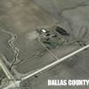
The top image is the drone photo, camera was pointed straight down.
The Red circle is my guess for the image center.
Lower image is a save from Google Earth. Placemark looks pretty close to me.
If you want to use some map deal and go just north of Dallas Center Iowa and check me out, go ahead.
By the way, on the lost drone. A grouping of about light colored corn husks, sure can look like a white drone.
My 1000 pictures, plus video did not work.
About six weeks later, a neighbor found my drone in the field just to the east. It was OK, charged battery and it flies again.
Edited by Robert W Greif 3/18/2017 17:17
 (DJI_0131.JPG) (DJI_0131.JPG)
 (Lat & Log.jpg) (Lat & Log.jpg)
Attachments
----------------
 DJI_0131.JPG (257KB - 305 downloads) DJI_0131.JPG (257KB - 305 downloads)
Lat & Log.jpg (118KB - 321 downloads)
|
 Geo referenced photos

