Dallas Center IA 515-720-2463 | It may be a good time to check out your farming operation on Google Earth.
Just discovered new images a few minutes ago. Noticed them in the only two places I looked.
South of the Quad Cities, Calmer Cornheads shop and Marion's farm.
Also around my home, eastern Dallas County Iowa.
Probably a whole lot more.
The date at least at my place is September 14, 2012. Corn picking is in full swing.
Found my renters picking at the Adin Hawbaker farm. Unloading on the go, 9660 and Ez-Trail cart.
Also folks just up the road from me with their Quad Trac disk ripping.
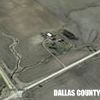
Line in at the Coop to get on the scale. And trucks unloading.
I found my brother's Gleaner N6 sitting at the north end of the field by R30. No truck.
Looked the highway all the way to the Coop. Didn't find the Diamond T. Even 'drove' out to Moss Brothers, AGCO dealer. figured he might be out there.
On September 14 I was on the way home from Husker Harvest Days. Lost in the great state of Wyoming.
By the shadows, it is about noon. About noon on Sep 14, I was climbing Independence Rock. Think I will take a look.
I did see that there was zero drown out in my pond this year. First time in about ten years.
Sure is fun to see people out farming.
And I have got to get pictures figured out on this Mac.
The problem is finding them.
May post from another putor.
The date of the Google Earth image is in the lower left corner.
And I now have four from around home.
This one is at the Coop.
More in a lower posting.
Edited by Bobby Greif 11/8/2012 13:32
 (Coop.jpg) (Coop.jpg)
Attachments
----------------
 Coop.jpg (51KB - 481 downloads) Coop.jpg (51KB - 481 downloads)
|
 See Yourself on Google Earth

