We got our Yearly Weather outlook briefing from Aaron Johnson who works at the NWS in Dodge City on Friday. As I have posted before.. http://talk.newagtalk.com/forums/thread-view.asp?tid=438859&posts=9&highlight=Weather outlook&highlightmode=1#M3533069 He is the guy whom I talked about last year who follows the PDO (Pacific Decadal Oscillation Index ) and the AMO (Atlantic Multidecadal Oscillation Index ) for it's agricultural impacts. When you are looking at 110+ years of data.. adding 12 months doesn't change things much.. Basically it was the EXACT SAME SPEECH as last year.. but tined with a little more optimism. Which again this year.. pretty much.. the same. I blogged about a pretty decent NOAA weather outlook in February.. with a good outlook. http://talk.newagtalk.com/forums/thread-view.asp?tid=445209&posts=38&highlight=Weather outlook&highlightmode=1#M3599863 "Your problem here in the plains is that you are missing the El Nino.. something that we have not seen.. in sufficient force for five years. Ja!." where we talked about the expected coming EL Nino.. which.. "Looking at History.. You had a bad 2011 Ja.. which was worse than 1980.. worse than 1981.. similar to the three years in the 1950's Ja,. and the 5 years in a ROW Ja in the 1930's.. that was a bad one.. "
"Now currently the El Nino La Nina cycle is NEUTRAL which means.. well it means that we can not forecast one way or the other.. El Nino means different things for different area's.. it means that this area COULD expect to see wetter conditions.. and because the jet stream shifts that other area's COULD see not as wet.. La Nina most likely sees a jet Stream that is further north.. pushing cold and wet moisture through the Dakota's..
In 2011.. you got No rain south of I-70 and yet North.. they had the flooding rains that flooded the Upper Missouri later.. this is typical of La Nina...Ja!"
"Now given the Neutral condition of the El Nino La Nina cycle and the OTHER factors the PDO.. the AMO.. the MJO.. (golly what am I missing? there's a couple other things he threw out there... )
"It's complicated" (yal no kidding.. )
but we can expect an improvement in the cycle.. "you are over due for improvement Ja! and we can expect.. in fact El Nino could show up in 2 weeks and it could start raining 6 weeks later."
hmm.. 2 weeks + 6 weeks.. = March.. in time to save my wheat..?? or at least emerge it by then....???
But unfortunately we are not looking for a BIG improvement.. afterall with a historical average precip in Garden City this week of 0.14" 150% of that is still only 0.21" so the extra 0.07" can get used on a windy day...
The question is going to be WHETHER the EL NINO SHOWS up in time before the SEASONAL AVERAGE PEAK RAINS.. IF the EL Nino does Not show up until August you are Kaput! JA?!? well.. as we all know the wet period did not show up in time last year to save much of the HRW Wheat crop. But we did start getting rains in June and July which continued on across Mizzou and Illinois and Indy to produce a bumper corn crop. ja?!? .. I'll go into a little more detail.. First.. we are STILL not triggered on El Nino.. http://www.cpc.ncep.noaa.gov/products/analysis_monitoring/lanina/enso_evolution-status-fcsts-web.pdf but we are oh so close.. currently described as El Nino lite?? But most models are STILL LOOKING for an expected El Nino. Which is starting to bring some more moisture into the Southern plains.. (at the expense of the Northern Plains and Canadian Prairies? Notice the yellow growing in the Dakota's...) Given the HOLE in the Subsoil moisture conditions of the Southern High Plains.. 
http://droughtmonitor.unl.edu/ we'll need/take it. Then Johnson goes into his longer AMO/PDO cycle.. 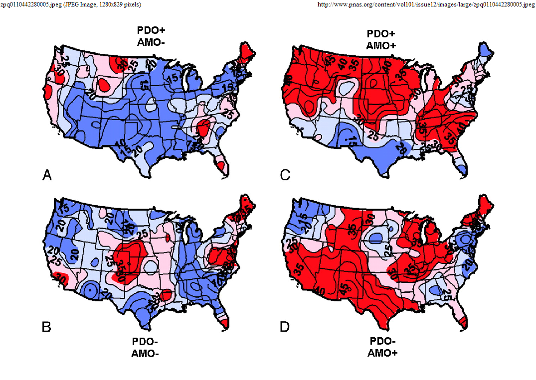
which..(although written in August of 2009..) this blog does a pretty decent job of explaining it.. http://www.kktv.com/blogs/talkweather/55529787.html Johnson took all the air out of the room two years ago when he opened his presentation with this statement.. "You guys.. unless you are really young.. have probably lived through the Wettest part of the cycle for your lives. The 1980's were the peak beneficial period of favorable weather for crops. and that will return again.. in about 20 or 30 years.." That would be "A" above a +PDO and a -AMO.. he thinks we are currently in "D" which is the total opposite with a -PDO and a +AMO.. which back to my link above.. http://www.kktv.com/blogs/talkweather/55529787.html "Simply put, if the PDO is in a positive or warm phase, there are more frequent and stronger El Nino episodes. Between 1980 and 2000, the PDO was very positive and thus we experienced more El Nino's and less drought. Since roughly the year 2000, the PDO has been largely negative. Thus, we have experienced more La Nina episodes and that has resulted in more drought years. When I say "we" I am obviously talking about Colorado. While this isn't the only player in our long range weather patterns, it certainly is influential. Usually when we have an El Nino, we don't have to worry about drought. When we have a La Nina episode, our drought concerns increase bigtime. By following the PDO and it's phase changes, one can determine if we need to have drought thoughts on our mind or not. The warm phase of the PDO may also explain why the late 80's and 90's were some of the warmest times on record. Thus, fueling global warming/climate change talk. However, if you look back through history a negative PDO ( cold phase ) has the opposite impact. The 1970's were an unusually cool time across the US and this is while the PDO was negative. Nobody was worried about global warming or climate change at that point...lol. Right now, the PDO is in a negative or cold phase and the AMO is positive. If you buy the above graphic, we should be worried about the prospects of drought." THIS WAS WRITTEN IN 2009.. before the 2011 and 2012 droughts!! WOW!! (gulp) Now Johnson agrees with this.. However, he is looking for the PDO to flip.. going to "C" in the cycle above a +PDO and a +AMO.. some time over the next couple of years.. "maybe by 2016.." which.. "is going to shift the drought outlook from the Southern Plains to the Northern Plains.. All those guys that are planting corn.. are gonna have to drag the wheat drills back out." Which is pretty significant considering that we have added about 12 to 20 myn acres to Corn and Beans from other crops (mainly wheat) in these areas.. (gulp.) so "there ya go." That's what he said this year. For us he thought that our wet period that it appear we have been in since about Last June would be "running out" by about "mid summer of 2015." ?? "Last year you guys needed to STALL and WAIT on the rains.." Which we did.. and they came. "THIS YEAR.. Ya'll might wanna Giddy Up!!.. plant Corn vs Soybeans.. Corn vs Sorghum.. and get it in before the water shuts off.. and the heat comes back." but "I could be wrong" I just look at the statistics and the odds.. Ma Nature does what she wants.. no matter what the odds are. All I know is that.. he's been pretty spot on. fwiw.
Edited by JonSCKs 12/20/2014 15:39
|  Yearly Weather outlook.. ja!

